Rapid and Accurate Disaster Assessment Using Drones
Drones have revolutionized disaster assessment and response by providing rapid, accurate, and real-time data to aid decision-making during emergencies. This service uses drones equipped with advanced sensors and imaging technologies to assess the extent of damage, map affected areas, and support rescue and recovery efforts in the aftermath of natural or man-made disasters.
What is Rapid Disaster Assessment with Drones?
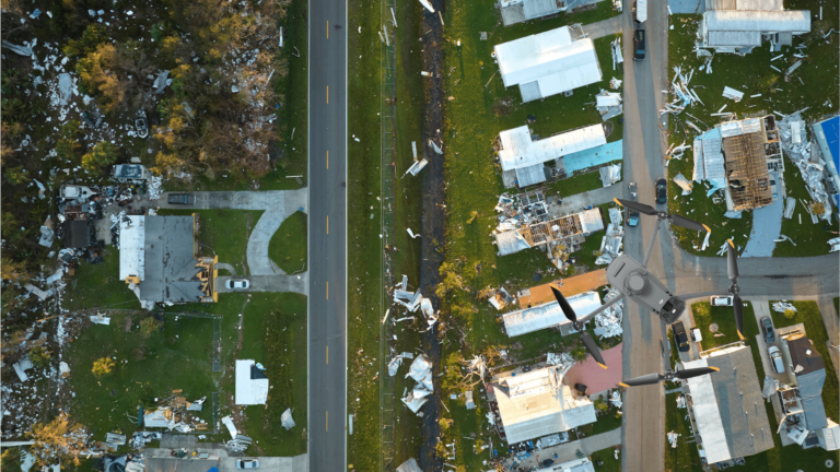
This service involves deploying drones immediately after a disaster to collect critical data from affected areas. The drones capture high-resolution images, videos, and other sensor data (such as thermal imaging and LiDAR scans) to provide a comprehensive overview of the situation. This information is processed and analyzed to create actionable insights for emergency responders, government agencies, and relief organizations.
Key Features of the Service
Speed and Accessibility:
Drones can be deployed within minutes, reaching affected areas quickly, even those inaccessible by traditional means.
High-Resolution Imaging:
Captures detailed aerial visuals to identify damage to infrastructure, property, and natural landscapes.
Thermal Imaging:
Locates survivors, trapped individuals, or hotspots in fire scenarios.
3D Mapping and LiDAR Scans:
Creates accurate 3D models of affected areas for damage assessment and planning recovery efforts.
Real-Time Data Transmission:
Provides live feeds to emergency command centers for immediate decision-making.
Scalability:
Can be used for small-scale incidents or large-scale disasters across extensive regions.
How Does It Work?
Deployment:
Teams deploy drones equipped with the necessary sensors and imaging systems to the disaster zone.
Data Collection:
Drones fly pre-programmed routes or are manually piloted to capture relevant data.
Data Processing:
Collected data is processed using advanced software to create maps, models, and reports.
Analysis and Reporting:
Insights are provided to authorities, including the extent of damage, areas requiring immediate attention, and potential hazards.
Applications of Disaster Assessment Drones
Post-Disaster Damage Assessment:
Evaluate the impact of earthquakes, hurricanes, floods, wildfires, or explosions.
Determine structural damage to buildings, roads, and bridges.
Search and Rescue Operations:
Locate survivors using thermal cameras and high-resolution imaging.
Guide rescue teams to areas of highest priority.
Environmental Monitoring:
Assess damage to ecosystems, forests, and waterways.
Monitor oil spills, chemical leaks, or other environmental hazards.
Disaster Preparedness and Training:
Use data from past disasters to simulate scenarios and improve future response plans.
Infrastructure and Utility Assessments:
Inspect power lines, pipelines, and communication networks for damages.
Benefits of Using Drones for Disaster Assessment
Rapid Response:
Collect data in minutes, enabling faster deployment of resources.
Enhanced Safety:
Reduces the need for human teams to enter dangerous or unstable areas.
Cost-Effective:
Minimizes the need for expensive helicopters, planes, or large teams on the ground.
Comprehensive Coverage:
Provides a bird’s-eye view of large areas, offering a clear understanding of the scope of the disaster.
Accurate Data:
High-resolution imagery and advanced sensors ensure precise assessments.
Deliverables:
Aerial Images and Videos: High-quality visuals for immediate situational awareness.
Orthomosaic Maps: Detailed maps of affected areas for planning and logistics.
3D Models: Interactive models of disaster zones for damage analysis.
Thermal Imaging Reports: Insights on heat signatures to locate survivors or identify hazards.
Actionable Insights: Reports with prioritized recommendations for relief and recovery efforts.
By leveraging drones for rapid and accurate disaster assessment, emergency response teams can save lives, reduce risks, and streamline recovery operations, providing essential support when it matters most.